Task II.G: Navigation and Flight Planning
Lesson Overview
- Objective
-
The student should develop knowledge of the elements related to navigation and flight planning as required in the different applicable tasks in the ACS.
- Reference
-
-
FAA-H-8083-25B, Pilot Handbook of Aeronautical Knowledge (Chapter 16)
-
- Key Elements
-
-
Time, distance, and fuel calculations
-
Navigation
-
Lost procedures
-
- Elements
-
-
Terms
-
Aeronautical charts
-
Pilotage
-
Dead reckoning
-
Radio navigation
-
Weather check
-
Flight planning
-
Fuel consumption and flight information
-
Using a flight log
-
Using a flight plan
-
Diversion to an alternate
-
Lost procedures
-
- Equipment
-
-
White board
-
Markers
-
References
-
- Schedule
-
-
Discuss objectives
-
Review material
-
Development
-
Conclusion
-
- Instructor Actions
-
-
Discuss lesson objectives
-
Present lecture
-
Questions
-
Homework
-
- Student Actions
-
Participate in discussion Take notes
- Completion Standards
-
The student can properly and confidently plan and execute a cross country flight to a chosen destination, and understands the procedures for diversions and lost situations.
Instructor Notes
- Attention
-
This is what leads into using everything you have learned so far and flying yourself somewhere!
- Overview
-
Review Objectives and Elements/Key ideas
- What
-
Navigation and flight planning is the process of planning and executing cross country flights
- Why
-
This information will make planning flights easier and more organized and provide procedures for different situations that may arise during the flight.
Lesson Details
Navigation and flight planning is an involved and detailed subject with numerous terms. These should first be defined before use in the subsequent sections.
Terms by Category
Navigation
-
True course — the intended/desired direction of flight as measured on a chart clockwise from true North.
-
True heading — the direction of the longitudinal axis of the airplane with respect to true North.
-
Magnetic course — true course corrected for magnetic variation.
-
Compass heading — aircraft heading read from the compass. Derived by applying correction factors for variation, deviation, and wind to true course.
-
Deviation — compass error due to magnetic disturbances from electrical/metal parts in the airplane. Correction displayed on compass correction card near magnetic compass.
-
Variation — angular difference between true north and magnetic north, shown by isogonic lines on sectional charts.
Atmospheric
Standard pressure — 29.92`" Hg Standard temperature — 15°C
Altitudes
-
Indicated Alt – Altitude read directly from the altimeter after it’s set to the current altimeter setting
-
Pressure Alt – Height above the standard pressure level of 29.92 in Hg -
-
Obtained by setting 29.92 in the barometric pressure window and reading the altimeter
-
-
Density Alt – Pressure altitude corrected for nonstandard temperatures -
-
Directly related to an aircraft’s takeoff, climb, and landing performance
-
-
True Altitude – The true vertical distance of the aircraft above mean sea level (MSL)
-
Airport, terrain, and obstacle elevations found on aeronautical charts are true altitudes.
-
-
Absolute Altitude – The vertical distance of the aircraft above the surface of the earth (AGL)
Airspeeds
-
Indicated (IAS) – The speed of an aircraft as shown on the airspeed Indicator
-
Calibrated (CAS) – Indicated airspeed of an aircraft, corrected for installation and instrument errors
-
Equivalent (EAS) – CAS corrected for adiabatic compressible flow for the particular altitude
-
True (TAS) – The speed at which an aircraft is moving relative to the surrounding air
-
Equal to CAS corrected for density altitude
-
-
Groundspeed (GS) – The speed of the aircraft in relation to the ground
-
Equal to TAS corrected for wind(tailwind/headwind)
-
Aeronautical charts
Provide information that allows pilots to track their position and enhance their safety.
Types of charts
-
Sectional chart - Most commonly used chart. Revised semi-annually. Provides airport data, navigational aids, airspace, and topography to scale (1:500,000—1`" is 6.86 NM).
-
VFR terminal area chart - helpful when flying in or near Class B airspace. They provide a more detailed display of topographical info, to a scale of 1:250,000 (1`" is 3.43 NM).
Topographical information — elevation levels, visual checkpoints (roads, railroads, power lines, aerial cables, landmarks, …)
Aeronautical information — visual/radio aids to navigation, airports, controlled airspace, restricted areas, obstructions, … Check publication date to make sure charts are current.
Check publication date to make sure charts are current. Possible revisions — radio frequency changes, new obstructions, runway/airport closures, other flight hazards.
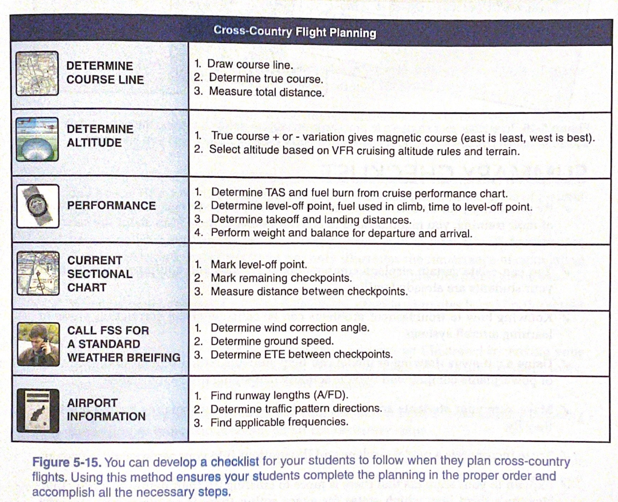
XC Planning Checklist (Jeppeson GFM)
Pilotage
-
Navigation by reference to landmarks or checkpoints. Can be used on any course that has adequate checkpoints, but is commonly used with dead reckoning and VFR radio navigation.
-
Becomes difficult in low visibility or in areas that lack prominent features. Checkpoints—prominent features that can be readily identified by other features (roads, rivers, railroad tracks, power lines). New roads/structures may not appear on chart.
-
Choose checkpoints as course boundaries to avoid drifting too far off course.
-
Do not rely on a single checkpoint — if you miss one, maintain heading and look for the next one.
Dead reckoning
-
Navigation solely by computations based on time, airspeed, distance, and direction. Heading and groundspeed obtained by adjusting for wind.
-
Used with pilotage except for flights over water. Constantly monitor heading and groundspeed, and use pilotage to correct with observations from checkpoints.
-
Ideally, use with radio navigation and pilotage to confirm.
Radio navigation
Predetermined path followed using radio waves. Tune appropriate navigation facility and control ground track based on the instrument’s indication. Can use ground stations or space satellites that transmit signals to navigation radio receivers in the airplane.
-
VOR
-
NDB
-
LORAN-C
-
GPS
Weather check
-
Obtain weather briefing—shows where problems may occur during the flight.
-
Pilot must be familiar with weather for the flight [FAR 91.103]
-
Use good judgment in deciding if to take the flight.
-
Consider weather factors in relation to the equipment to see if the plane can handle the flight.
-
Should be a no-go decision if…
-
Thunderstorms, especially embedded
-
Fast-moving fronts/squall lines
-
Moderate turbulence
-
Icing
-
Fog, visual obscurations
-
-
Pilot mental and physical condition can affect your ability to handle problems — sick, tired, upset, depressed, IMSAFE.
-
Recent flight experience is important in making the decision
Flight planning
Plot the course—draw a line from point A to point B. Can be direct (single straight line) or not direct (two or more straight line segments).
Fuel stops
-
Personal comfort or regulations, whichever is higher.
-
Need enough fuel to fly to the point of intended landing, and an extra 30 minutes of flight during the day, 45 minutes at night, at normal cruise power.
Checkpoints
-
Select checkpoints along route and note them.
-
Should be easy to locate—large towns, lakes and rivers, combinations of recognizable points (towns with an airport, highway network, railroads going in/out
-
Choose yellow towns on charts, not those signified by a small circle, unless flying over an isolated area.
Unforseen Events
-
Survey the route of flight—do you have available alternate airports along the route? What terrain could impact emergency landings?
-
Ensure the route does not penetrate restricted or prohibited areas.
Mentally prepare for any type of emergency situation and the appropriate action to take.
Fuel consumption and flight information
-
Distance — measure length of course.
-
Time — divide distance by groundspeed (correct TAS for wind).
-
Total fuel consumption — multiply projected hourly fuel burn by time.
-
Repeat calculation for every segment of the flight where the groundspeed changes.
True course
-
Direction of line connecting the points. Measure clockwise in degrees from True N on the mid-meridian.
True airspeed
-
Use the charts in the performance section of the POH and a flight computer
WCA
-
Use the back side of a flight computer to calculate. (+W, -E)
True heading
-
Direction to point the nose to get the desired course. Degrees clockwise from True N.
Variation
-
Obtain from isogonic line on charts.
Magnetic heading Deviation
-
Intermediate step in conversion—variation is applied to true heading
-
Obtain from card in airplane. Add or subtract to magnetic heading as necessary.
Compass Heading
-
Compass reading—apply deviation to magnetic heading. Used for desire course.
Total distance
-
Measure length of true course line on chart.
Groundspeed
-
Use backside of flight computer to adjust for wind.
ETE
-
Estimated time en route—total distance divided by groundspeed.
Fuel rate
-
Gallons of fuel per hour used during flight—predetermined.
Fuel consumption
-
ETE x fuel rate
Using a flight log
Navigation log assists in planning and conducting the flight. Helps with organization. Logical sequence of information so that the pilot can track the flight progress. Put frequencies in order so that they are easy to find and use.
Flight plans
-
Provides information to search and rescue.
-
Can file on ground or in air:
-
Call FSS (1800-wx-brief) or use DUAT to file.
-
After takeoff, contact the FSS (radio call) to give them the takeoff time to activate the flight plan.
-
Once filed, held for an hour after proposed departure time.
-
Remember to close the flight plan! Search and rescue initiated 30 minutes after the scheduled arrival time.
-
Diversion to alternate
May be unable to make it to the planned destination (weather, malfunctions, poor planning, fuel, fatigue/illness, …)
Check route for suitable landing areas and nav aids that you can use in a diversion before flight. When diverting, use shortcuts and rules of thumb in calculations. Can choose an alternate from the sectional, or use the “NRST” function on the GPS.
-
To divert…
-
Confirm present position on sectional chart.
-
Divert immediately toward the alternate using shortcuts and rule of thumb calculations.
-
Once established on course, note the time.
-
Use winds aloft nearest the diversion point to calculate heading and groundspeed, a new arrival time and fuel consumption.
-
Prioritize flying when dividing attention between navigation and planning.
-
Lost procedures
Always know where you are to avoid becoming lost. Plan ahead, know what the next landmark, and anticipate NAV indications. If the nav systems and visual observations do not confirm what you expect, take corrective action.
Five C’s
-
Climb — allows you to see more ground, increases chances of spotting landmarks, improves radio reception, extends transmitter range, increases radar coverage.
-
Communicate — use chart frequencies (including RCO frequencies) to ask a controller for radar vectors. If situation becomes threatening, squawk 7700 and communicate on 121.5.
-
Confess — tell any ATC facility that you are lost.
-
Comply — comply with any ATC suggestions.
-
Conserve — reduce power and airspeed to maximum endurance or maximum range, whichever is appropriate.
Remember, don’t Panic!
- Some additional tips
-
-
If near a town, you can usually read the name of the town on the water tower.
-
Compare the heading indicator to the magnetic compass, and note the direction of error before resetting (can help determine if you are left or right of course—if the compass indication is greater than the heading indication, you may be right of course).
-
Use navigational radios (VOR/ADF) to plot your position in relation to two nav aids. Use the GPS to determine your location.
-
Conclusion
Cross country flight planning requires a lot of preflight work but the flight itself is worth the time. It also helps to prevent getting lost and keeps us away from potentially dangerous or bad weather.
ACS Requirements
To determine that the applicant exhibits instructional knowledge of the elements of navigation and flight planning by describing:
-
Terms used in navigation.
-
Features of aeronautical charts.
-
Importance of using the proper and current aeronautical charts.
-
Method of plotting a course, selection of fuel stops and alternates, and appropriate actions in the event of unforeseen situations.
-
Fundamentals of pilotage and dead reckoning.
-
Fundamentals of radio navigation.
-
Diversion to an alternate.
-
Lost procedures.
-
Computation of fuel consumption.
-
Importance of preparing and properly using a flight log.
-
Importance of a weather check and the use of good judgment in making a “go/no-go” decision.
-
Purpose of, and procedure used in, filing a flight plan.